


About Dishaank(KSRSAC)
Learn more about this application's features and capabilities.
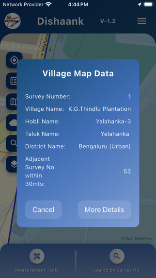
Dishaank is a specialized geographic information system (GIS) application developed to provide users with clear access to land records and survey data in Karnataka. This software serves landowners, real estate buyers, and legal professionals by solving the problem of identifying exact property boundaries and land survey numbers on the ground. By leveraging GPS technology, the tool overlays survey maps onto the user's live location, ensuring transparency in land dealings and reducing the risk of property disputes.
Key Features
- Real-time GPS Mapping: Track your current location on digital survey maps to identify specific land parcels.
- Survey Number Retrieval: Access detailed survey information for any location within the state of Karnataka.
- Village Map Overlays: View historical and current village maps integrated with modern satellite imagery.
- Land Category Identification: Distinguish between various types of land, including government, private, and forest areas.
- Offline Capabilities: Access previously viewed map data even in areas with limited mobile connectivity.
Use Cases
- Property Verification: Check the survey number of a plot before purchasing to ensure the seller's claims match official records.
- Boundary Identification: Locate the physical limits of a land parcel during site visits or agricultural planning.
- Government Compliance: Verify if a specific area is designated as protected or government-owned land.
- Legal Documentation: Use the app to gather preliminary data for land-related legal queries or title searches.
Why Choose Dishaank
This platform provides a direct link to the Karnataka State Remote Sensing Applications Centre database, offering high-precision spatial data. It is an essential tool for anyone requiring authenticated land information without visiting administrative offices, promoting efficiency and digital governance in real estate management.
Pros and Cons
Pros
- High accuracy in mapping survey boundaries.
- Simple, user-friendly interface for non-technical users.
- Reduces dependency on physical land record intermediaries.
Cons
- Geographic coverage is limited to the state of Karnataka.
- Requires a stable GPS signal for precise real-time tracking.
Final Verdict
Dishaank is a highly reliable platform for accessing spatial land records and verifying property details on the go. It effectively bridges the gap between official government data and the end-user, making it a vital resource for transparent land management.
Ratings & Reviews
Please log in to write a review.
No reviews yet. Be the first to rate!